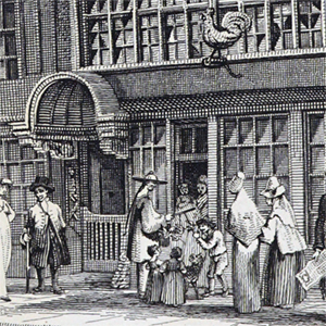
Leadenhall Street
Names
- Leadenhall Street
- Leaden Halle Streete
Street/Area/District
- Leadenhall Street
Maps & Views
- 1553-59 London (Strype, 1720): Leadenhall Street
- 1553-9 Londinum (Braun & Hogenberg, 1572): Leadenhall Street
- 1553-9 London ("Agas Map" ca. 1633): Leaden hall street
- 1560 London (Jansson, 1657): Leadenhall Street
- 1593 London (Norden, 1653 - British Library): Leaden Hall Streete
- 1593 London (Norden, 1653 - Folger): Leaden Hall Streete
- 1658 London (Newcourt & Faithorne): Leden hall Street
- 1666 London after the fire (Bowen, 1772): Leadenhall Street
- 1666 Plan for Rebuilding the City (Wren), 1724: Leaden Hall Street
- 1677 A Large and Accurate Map of the City of London (Ogilby & Morgan): Leadenhall Street
- 1677 A Large and Accurate Map of the City of London (Ogilby & Morgan): Leadenhall Street
- 1677 A Large and Accurate Map of the City of London (Ogilby & Morgan): Lime Street
- 1677 A Large and Accurate Map of the City of London (Ogilby, Morgan): Leadenhall Street
- 1677 A Large and Accurate Map of the City of London (Ogilby, Morgan): Threadneedle Street
- 1720 London (Strype): Leadenhall Street
- 1736 London (Moll & Bowles): Leadenhall Street
- 1746 London, Westminster & Southwark (Rocque): Leaden Hall Street
- 1761 London (Dodsley): Leadenhall Street
- 1799 London (Horwood): Leadenhall Street
Descriptions
from A Dictionary of London, by Henry Harben (1918)
Leadenhall Street
East from Cornhill to Aldgate (P.O. Directory).
The east end is in Aldgate Ward, the western portion in Lime Street Ward (O.S.).
First mention: 1622 (Remembrancia, p. 51).
In former times this street seems to have been included in Aldgate and Cornhill, or to have been called the "high Street."
"Aldgate Street" as far as Lime Street (S. ed. 1603, p. 140).
The church of St. Andrew Undershaft (See s.v.) is often styled in early records. "St. Andrew upon Cornhill," which would seem to suggest that that part of Leadenhall Street was then included in Cornhill.
Largely rebuilt during the later years of the 19th century and old houses and shops taken down.
Under No. 71 was the crypt of the chapel of St. Michael, filled in and destroyed 1870. The discovery suggests that the level of the street has been considerably raised since the original foundation of the chapel.
Houses at the east end taken down 1760 to widen the street.
In 1766, after the fire in Leadenhall Street, the remains were discovered of an old Gothic church, or of the crypt of the church, on the north side of Leadenhall Street at its junction with Bishopsgate Street, about 40 ft. long and 26 ft. wide (Gent. Mag. Lib. XV. 82).
It seems unlikely that this can be the crypt of the original church of St. Peter, Cornhill, as the remains suggest a church of later date than the original foundation, and there is no evidence as to the rebuilding of this church on a different site in the 12th or 13th centuries. On the other hand there are no records of any other church existing on or near this site in early times.
See Leaden portch.
Named after the Leadenhall (q.v.).
A very fine tessellated Roman pavement was found in this street opposite the eastern end of the portico of the East India House, 9 ft. 6 in. below the street level, and another 19 ft. below (R. Smith, 57).
Walls found under Leadenhall Market extending nearly from Gracechurch Street to Whittington Avenue at a depth of 18 ft. (Arch. LX. 224).
from Lockie's Topography of London, by John Lockie (1810)
Leaden hall street, a very spacious str. of good Buildings, betn Graschurch str. W. and Aldgate E. L. 460 Yds, and from TL. 600 Yds NWly.
from London and Its Environs Described, by Robert and James Dodsley (1761)
Leadenhall street extends from the end of Cornhill, at the corner of Gracechurch street, to Aldgate street within.
from Lockie's Topography of London, by John Lockie (1810)
Leadenhall-Street, Gracechurch-St.—at 98, op. Cornhill, where the numbers begin and end, viz. 1 and 158, it extends to Aldgate.
from A Topographical Dictionary of London and Its Environs, by James Elmes (1831)
Leadenhall-St., Gracechurch-street, is opposite Cornhill, and extends to Aldgate.
from London Past and Present: Its History, Associations, and Traditions, by Henry Benjamin Wheatley and Peter Cunningham (1891)
Leadenhall Street runs from Cornhill to Aldgate. About 1582 a mathematical lecture was founded to be read in the Staples Chapel in Leadenhall Street. The scheme, which received the approval of the Privy Council, had for its object the instruction of the citizens in military matters. It was transferred in 1588 from Leadenhall Street "to the house of Mr. Thomas Smith in Grass [Gracechurch] Street."1 The house of Sir Thomas Allen, Lord Mayor in the critical year 1660, was in this street. Here Monk dined with him on the day on which he finally broke with the Parliament. Gibbon's great-grandfather Matthew, as the historian relates, "did not aspire above the station of a linen-draper in Leadenhall Street;" and his grandmother was the "daughter of Richard Acton, goldsmith in Leadenhall Street." He himself was born at Putney. Here Peter Motteux, the translator of Don Quixote, kept an East India shop, or India house, as it was then called. The shop was continued by his widow. [See Motteux's.]
The Widow Motteux at the Two Fans in Leadenhall Street, is leaving off Trade, and will sell off her goods wholesale or retail at reasonable rates. The House to be Lett.—The Daily Courant, February 26, 1722.2
The East India House stood on the south side of this street, just beyond the entrance to Leadenhall Market, where now stands the vast pile of chambers erected (1862–1864) by the East India House Buildings Company, under Mr. E.N. Clifton. At the King's Head Tavern, in the reign of William III., Sir John Fenwick and his associates met to plot for the restoration of James II. The sign was afterwards changed to the King's Arms. It was taken down in 1867 to make way for the new Offices of the Peninsular and Oriental Steam Navigation Company—a large and stately Italian edifice designed by Mr. E.N. Clifton.
During the last twenty years the appearance of Leadenhall Street has been much altered by removal of old houses and dark old-fashioned shops, of which it retained a larger proportion than any other City street, and the erection instead of great piles of chambers and offices. Besides those already noticed, the New Zealand Chambers, on the south side near Lime Street, a large red brick building with three tall bay and dormer windows, erected by Mr. Norman Shaw in 1873, and remarkable as the building which led the way to the now fashionable Queen Anne style of street architecture, though this is rather Jacobean in date and of a quainter fancy than those which have followed it. The great renaissance structure, Leadenhall House (J.L. Holmes, architect, 1879), with its lofty stone front, exuberant in carvings and polished granite shafts, and its nests of offices piled one above another, and stretching back to a depth of nearly 200 feet, may be taken as characteristic examples of this new and most costly class of civic street architecture. On the north side are the churches of St. Katherine Cree and St. Andrew Undershaft; and nearly opposite the latter is Sussex Hall. Under No. 71 was an exquisite Gothic crypt 46 feet by 17 feet. It was a vestige of the chapel of St. Michael, erected 1189. The house was pulled down October 1868. No. 84 cost about £12,000 to rebuild in 1888–1889. The kitchen of the house No. 153 contains a curious early English crypt,3 supposed to be part of the former church of St. Peter. Nos. 156 and 157 are portions of the site where the little midshipman in Dombey and Son used to hang out. The "Ship and Turtle Tavern" (Painter's), Nos. 129 and 130, is famous for its turtle.
2 See also Spectator, Nos. 288, 552.
3 There is a view of it in the Gentleman's Magazine for 1766.